
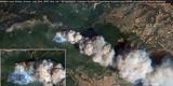
Πώς φαίνονται οι πυρκαγιές στην Αττική από δορυφόρο
Είναι εντυπωσιακές οι φωτογραφίες που δόθηκαν στη δημοσιότητα από το σύστημα Copernicus. Δορυφόροι που χαρτογραφούν φυσικές καταστροφές, έδωσαν στη δημοσιότητα τις φωτογραφίες μέσω Twitter από τον ερευνητή Pierre Markuse.
A nice view of the Kineta wildfiresmoke plume reaching Athens here in this #Aqua #MODIS image.
— Pierre Markuse (@Pierre_Markuse) July 23, 2018
And a faux 3d animation of the smoke cloud of the Kineta wildfire. Created using a displacement map based on brightness so not really accurate but nice to look at. Full-size in better quality: https://t.co/fG4Plf96BJ … #wildfire #kineta #3d #animation pic.twitter.com/J7ljajTOMO
— Pierre Markuse (@Pierre_Markuse) July 23, 2018
And a #Copernicus #Sentinel- #Tropomi image showing the carbon monoxide emissions (CO total column) of the wildfire in #Kineta with parts of the smoke plume reaching Athens. @m_parrington @jmccarty_geo pic.twitter.com/1s4r0HVFLV
— Pierre Markuse (@Pierre_Markuse) July 23, 2018
.
φωτιάπυρκαγιά- Δημοφιλέστερες Ειδήσεις Κατηγορίας Ειδήσεις
- Σοκαριστική μαρτυρία: «Το Μάτι δεν υπάρχει πια σαν οικισμός...»
- Νέος πύρινος εφιάλτης στην Κόρινθο
- Εικόνες μαχαιριά στο Μάτι! Σαν άλλοι πρόσφυγες στην θάλασσα, για να ξεφύγουν από τις φωτιές!
- Νένα Χρονοπούλου: Οι συγκλονιστικές στιγμές που έζησε από τη φωτιά - Κάηκε το αυτοκίνητό της
- Σοκαριστικές εικόνες από το Μάτι: Εκατοντάδες πολίτες στην παραλία
- Φωτιά Μάτι: Έτσι βρήκαν τραγικό θάνατο 26 άνθρωποι στην ταβέρνα (vids)
- Φωτιά στη Ραφήνα: Η ανακοίνωση του Δημήτρη Τζανακόπουλου που σόκαρε το πανελλήνιο - (ΒΙΝΤΕΟ)
- Σοκ: Βρέθηκαν ακόμα 26 νεκροί στο Κόκκινο Λιμανάκι της Ραφήνας
- Εικόνες Πομπηίας στο Μάτι Ραφήνας με απανθρακωμένους ανθρώπους
- To οικόπεδο της τραγωδίας
- Δημοφιλέστερες Ειδήσεις Alfa Vita
- Βρέθηκαν οι σοροί ακόμη 26 απανθρακωμένων ανθρώπων στο Μάτι - Ήταν αγκαλιασμένοι σε απόσταση αναπνοής από τη θάλασσα
- Πώς φαίνονται οι πυρκαγιές στην Αττική από δορυφόρο
- Στη δημοσιότητα φωτογραφία από το οικόπεδο που βρέθηκαν οι 26 σοροί
- Χαλάει ο καιρός, έρχονται βροχές και πτώση της θερμοκρασίας
- O γερμανικός Τύπος για τις πυρκαγιές στην Αττική
- Χορήγηση υποτροφιών για σπουδές από την Περιφέρεια Βορείου Αιγαίου
- 10 Προσλήψεις εξειδικευμένων συνεργατών στο Εθνικό Θέατρο
- Σε ύφεση τα μεγάλα μέτωπα στην Κορινθία
- Τελευταία Νέα Alfa Vita
- Πώς φαίνονται οι πυρκαγιές στην Αττική από δορυφόρο
- Έτοιμοι οι φαρμακοποιοί της Θεσσαλονίκης να συνδράμουν σε ιατροφαρμακευτικό υλικό για τους τραυματίες των πυρκαγιών στην Αττική
- Χορήγηση υποτροφιών για σπουδές από την Περιφέρεια Βορείου Αιγαίου
- O γερμανικός Τύπος για τις πυρκαγιές στην Αττική
- Μεσίστια η σημαία της Βουλής
- Υποτροφίες για φοιτητές από το "Κληροδότημα Α. Γαζή"
- Μεταφορά οργανικής θέσης για Εκπαιδευτικό, η οποία προέρχεται από ΕΠΑΛ με μεταφερόμενους τομείς ή ειδικότητες
- 6 Προσλήψεις ερευνητών στο Εθνικό Μετσόβιο Πολυτεχνείο
- 92 Προσλήψεις στο Πανεπιστήμιο Πατρών - Η Προκήρυξη
- Τελευταία Νέα Κατηγορίας Ειδήσεις
- Τα συστήματα πλοήγησης των αυτοκινήτων θα μπορούσαν να βάλουν τέλος στα μποτιλιαρίσματα
- Δύο ημέρες και σήμερα, για 600.000 φορολογικές δηλώσεις
- Μεσίστια η σημαία στην ελληνική Βουλή για τους νεκρούς της φωτιάς
- Μητσοτάκης: Η πατρίδα μας βιώνει μια ανείπωτη εθνική τραγωδία
- Συγκλονιστικά στιγμιότυπα: Η καταστροφή της Αττικής από ψηλά (video)
- Φωτιά Αττική: Χρήσιμα τηλέφωνα για μέρη που προσφέρεται στέγη και φαγητό στους πληγέντες
- Πυροσβεστική: Στο 199 η δήλωση αγνοουμένων από τις πληγείσες από την πυρκαγιά περιοχές
- Μεσίστεια η σημαία της Βουλής
- Alert! Στους 49 νεκρούς ο τραγικός απολογισμός από τις φωτιές στην Αττική
- Εθνική τραγωδία - Δεκάδες νεκροί σε Νέο Βουτζά και Μάτι